


- Articles
- Posted
Wildfires in Syria: What is the Accurate Number? And What is the Actual Cause?
Environment statistics are the least elaborate statistics in Syria. Despite the increase in wildfire frequency during the past decade, and the impact of global climate change on the increase of wildfires worldwide, Syrian data do not regularly monitor these fires or they do not make it available to everyone. Also, what is being published about the wildfires and the losses in woodland areas vary to a large extent between international and local estimates.
One day, forest areas in Syria covered about 32% of Syrian land, and that was at the beginning of the twentieth century. Those areas decreased to less than 2.8% of total land areas, and the estimates of the area vary between 522–580 thousand hectares. This area that has been recorded since the nineties until today without any changes may have decreased by more than a quarter during more than 10 years that passed, and we may have lost more than 140 thousand hectares of the forests.
Official Estimates
(The Forests are Okay)!
In a study about climate and environmental changes in Syria published in 2018 in the National Center for Agricultural Policy, woodland areas and forests in Syria decreased by a rate of less than 2% and lost about 11 thousand hectares of their areas. The researcher points out that this small decline published in the official statistics results from publishing indicative figures during the crisis, and that it is not an accurate estimation. Besides, woodland areas and forests in Latakia Governorate, which consists an area of 14% of woodland in Syria, have not changed during all the years of the crisis, and that contradicts with the wide series of wildfires in 2016, as the area remained fixed on the figure 85 thousand hectares. Even in the periods before the crisis, the published agricultural statistics had not included the changes in natural woodland areas, but only changes in woodland areas based on the expansion of forestry operations and forestation. According to the data published in the research, the wildfires between 2010–2016 had caused damage in forest areas that approximated 21.5 thousand hectares of forestland, and that was through 3600 fires, the largest of which was in 2012 and most of which were in 2016.

International Estimates
(We Lost a Quarter of the Forests)!
Relying on the data of The European Forest Fire Information System (EFFIS), which is the international website for monitoring wildfires via satellite, the areas affected by wildfires in Syria during the period between 2008–2018 had reached approximately 130 thousand hectares, which is 23–25% of the Syrian forest areas according to its official estimates and the estimates of FAO. It is noteworthy that these estimates were accompanied by information taken from the report of the Agriculture and Forestry Directorate in Latakia, which estimated that Syrian forests have lost a quarter of their areas during the years of the crisis. This report is unpublished but is widely circulated according to a Syrian newspaper that has been suspended from working in Syria. However, the huge discrepancy between both statistics, particularly between 2015–2016, raises questions about the great disparities in figures, specifically about the inaccurate estimate of the size of the wildfires and their expansion in 2015.

The First Wave of Wildfires in 2020
No thorough official estimates were issued considering the first wave of wildfires during the months of August and September 2020, except from the Forestry Directorate of Hama Countryside, which indicated that the wildfires of the areas of al-Ghab and Musyaf included approximately 3895 hectares till the end of September. While the National Center for Remote Sensing in Lebanon monitored on September 21, 2020 an estimation of the total Syrian wildfires between August 11 – September 21 which amounted to 9000 hectares of forestland. The largest part of it was in Hama Governorate in the areas of al-Ghab and Musyaf by approximately 3970 hectares, then in separate areas in Latakia by approximately 4000 hectares, the highest of which is in al-Hefah with an area of approximately 2000 hectares. In addition to 400 hectares in Jisr Al-Shughur, and the rest is spread over in other areas in Talkalakh in Homs, Safita, Draykish, and al-Qadmus in Tartous, and they are all woodland areas.
The Second Wave
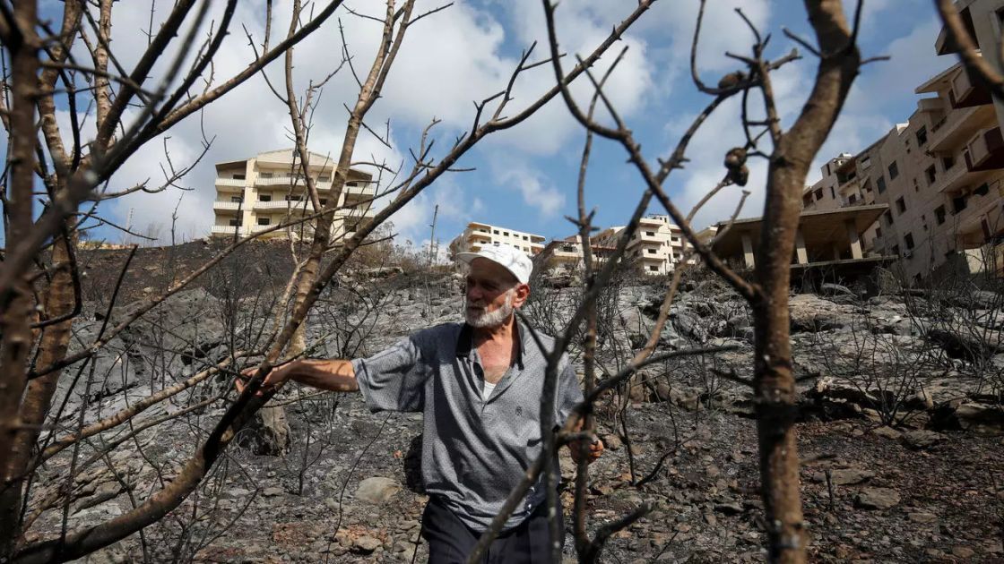
10% of olive trees in Latakia and 2% in Tartus. As for the wildfires in October that were spread over between woodland areas and reached many agricultural land, local estimates about them are still coming out consecutively. They indicated that the wildfires in Latakia have reached an area between 7200-8000 hectares of the land, and in Tartus an area that approximated 1225 hectares. However, estimates have not yet reached the burned lands in the western countryside of Homs, which were also affected by the fire, albeit by a lower amount. This indicates that the wildfires of the last three months have affected areas of approximately 18 thousand hectares of the lands distributed between woodland areas and agricultural land. Losses in this huge wave of wildfires varied, as it reached agricultural land and some harvests. The total number estimated of the people affected until now: more than 13 thousand families in Latakia, and more than 3000 families in Tartus, while other statistics have indicated that the number of displaced people at the time of wildfires in Latakia have reached 30 thousand families.
Olive trees are considered the most affected, as wildfires in Latakia affected 1.1 million olive trees, which is 10% of the total number of trees in the governorate, amounting to about 10 million trees, 9 million of which are in the stage of production. Whereas in Tartus, about half of the burned areas and more than 1000 hectares were land planted with olive trees, as 230 thousand trees were affected, which is 2% of the total number of trees estimated in the governorate, reaching 11 million trees. As for the damage of the wildfires on citrus in Latakia, it affected approximately 200 thousand trees, which is 2% of the total number of trees in the governorate. The Agriculture Directorate estimated the loss in citrus production at 17 thousand tons of the production of the governorate, which approximates 860 thousand tons. Many other losses reached apple and pomegranate trees, apiaries, poultry farms and livestock in both governorates, but lesser damage was dealt to olives and citrus. While estimated damages did not include the damage in woodland areas in the second wave, and the total data of the damages were not completed yet.

Much has been said about arson and the causes of the wildfires. In spite of the fact that the last wildfire wave was regional and affected Lebanon and occupied territories in Palestine, the frequency and intensity of the fires have raised doubts in Syria, which are based on a set of political and economic estimates. Even if the political interest in arson was fulfilled, as it is useful in sparking fear, chaos and disorder, and leading to direct damage in the livelihood of the inhabitance, which is a declared goal of the powers of chaos in all their political positions in Syria, the economic reasons related to the activity of seizing and investing woodland areas would not be any less important. Some are relating wildfires to the charcoal manufacturing, but the connection is not exactly accurate, because the charcoal manufacturing sector does not benefit from burning trees directly, as it needs to chop trees in a qualitative and selective way to convert them into expensive charcoal. On the other hand, wildfires lead to wide and organized investment of the woodland areas affected by fires through organizing their logging operations later under the pressure of fait accompli. Wildfires also allow the change of the structure of the woodland areas and open the possibility of using them for agricultural and real estate investment.
More importantly, the activity of the charcoal manufacturing sector might be the direct cause of these wildfires, especially that most of this sector is unorganized and its works are performed in the heart of the forests. It depends on building a big charcoal fire pits to burn green wood, and it can cause the spread of fire in a suitable atmosphere. As some estimates indicate that there are more than 1500 licensed charcoal fire pits, and there are more irregular unlicensed pits than licensed ones spread in most of the countryside of the coastal region.
According to some investigative reports, the production and supply chain of charcoal in regions of the Syrian coast goes through the following: lumberjacks sell green wood to owners of charcoal fire pits (pits in the ground used for burning tons of green wood to produce about 300 kg of natural charcoal). The sales price varies according to the type of firewood, but last year it ranged between 40-150 Syrian pounds per kg, from olives all the way to oaks, which are the most expensive. As for the owners of the charcoal fire pits, most of which are unlicensed, they sell them to big merchants and agents who receive the area with an amount that last year reached 500 Syrian pounds per kg of natural charcoal. However, the price varies a lot in cities for cafes and shops or for firewood used for heating, but it is never less than 1500 Syrian pounds per kg. Also, some merchants offer a lump sum in US dollar for the owners of the charcoal fire pits, which varies according to the amount and the type of firwood.
This trade includes profits that reach 300% and it relies on the need of the people of the countryside for any additional source of income. It also relies on the total legal and illegal activity of charcoal fire pits, which can be covered by armed people and its illegal trade can be organized by warlords, as this phenomenon is widespread and known in the region and is one of the economic activities for these people. Wildfires that reach tens of thousands of hectares could be a promised wealth and an important market. It allows changing the composition of agricultural land, seizing woodland areas, and taking advantage of expanding logging operations in an organized manner. So, if one wave of wildfires has destroyed this number of trees which reached more than 1.5 million, logging and charcoal trade have destroyed very large numbers of trees, but silently over the past years.
The Inability of Extinguishment
Finally, what can be said about the wildfires is the (defect) that has been revealed by the weakness of the ability to extinguish the fire, which is mainly due to the huge decline in spending on civil defense service. For example, Latakia Fire Brigade was concerned with fires that reached 85 thousand hectares of forestland, but it only had 34 fire engines. Each fire engine had to cover an average area of more than 200 hectares of the wildfires in the recent fire that extended over more than 7000 hectares in Latakia only. The series of fires also showed that the level of expenditure and services is so low to the point that the workers of the fire brigade are demanding wireless devices to communicate with each other that has not been afforded yet. The aforementioned study of agricultural policy indicates that the burned areas in one fire in Syria increased from 0.6 hectares for one fire in 2010 to 5.8 hectares for one fire in 2015, which bespeaks the huge decline in the ability to extinguish fires and to limit their impact. As a higher number of fires in 2010 have led to less damage in areas than in the years of the crisis, due to the decline in the total of capabilities, public services and expenditure, which also reflected on civil defense services and fire extinguishment in particular as mentioned before and on the capabilities of woodland centers.
The great fires that reached woodland areas and agricultural land throughout this year accentuate a number of issues; first and foremost is the lack of concern and obscuring this wealth, which is reflected in inaccurate official data and statistics that prove the area of forests in Syria, and reflects the concealment of reality or pretending not to see it, or at the very least, a lack of concern and appreciation of this wealth. On the other hand, some international comparisons that may not be completely accurate indicate that the Syrian forests may have decreased by a quarter during the years of the crisis, with all that this besets of permanent losses that may be irreparable, in addition to losses in biological environments, and plant species that exist in these forests.
The fires also reflect the decline in the ability of managing crises of such a size, which are crises that are expected to happen again under political circumstances that drive suspect parties to cause mayhem in any way. They are also expected to happen again under climate conditions that raise the number of fires across the world and in our region, and under economic circumstances that push towards the expansion of unorganized and unjust activity, which targets this wealth, and which could be the reason of starting the fires through charcoal fire pits or through the desire of seizing woodland areas and using it for investment. Managing these areas effectively requires expenditure, plans for crises and disasters, and equipment, but most importantly: it requires awareness of the size of a crisis of this kind and its future impact. It requires a national concept for dealing with environment, and finding policies that relate local inhabitance with these forests, and urge them to protect those forests through their well-organized benefit from them and not by pushing them under the weight of poverty to treat those forests cruelly with logging, turning trees into charcoal and transgression under cover of big traders and brokers.